MIT’s Localizing Ground-Penetrating Radar Could Be the Solution to Mapping and Sensing Challenges Facing Autonomous Vehicle Technology
Jennifer van der Kleut
Researchers at the Massachusetts Institute of Technology think they have a viable solution to one of the biggest obstacles facing autonomous driving technology.
Mapping and GPS technology is a crucial element for driverless transportation technology. There are millions of miles of roads across the globe - how do we map them all, so that our driverless car always knows how to get us to our destination?
With construction and development constantly changing the face of our cities and roads, updates will also constantly be needed. Plus, adverse weather conditions such as heavy rain, snow and fog can blur lines separating lanes and block sensors and cameras.
“Most [Autonomous Ground Vehicle] sensors cannot determine the vehicle’s location [in] adverse conditions,” MIT researchers wrote in a report released in November of last year that is making the rounds on the Internet again this week.
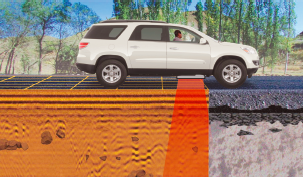
MIT’s Lincoln Laboratory has developed localizing, ground-penetrating radar (LGPR) in answer to those challenges.
LGPR utilizes a sensor that provides real-time estimates of a vehicle’s location even in challenging weather and road conditions.
“LGPR uses very high-frequency radar reflections of underground features to generate baseline maps and then matches current [ground-penetrating radar] to the baseline maps to predict a vehicle’s location,” MIT’s report explains. “The LGPR uses relatively deep subsurface features as points of reference because they are inherently stable and less susceptible to erosion or damage over time.”
The very high-frequency radio waves can penetrate all kinds of weather, from snow to heavy rain to fog, they added.